- Call Us Now : +91 933-658-5266
- Send Us Email : geovisioninfocom@gmail.com


GPS Surveying
GPS Surveying
WHAT IS DGPS AND WHY USE IT?
Differential Global Positioning System (DGPS) is an enhancementto Global PositioningSystem that provides improved location accuracy,from the 15-meter nominal GPS accuracy to about 10 cm in case of thebest implementations.
DGPS refers to using a combination of receivers and satellites toreduce/eliminate common receiver based and satellite-based errors reduce orbiterrors reduce ionospheric and tropospheric errors reduce effects of SA eliminatesatellite and receiver clock errors
Improve accuracy significantly 100’s of metres to metres to centimetres tomillimetres.
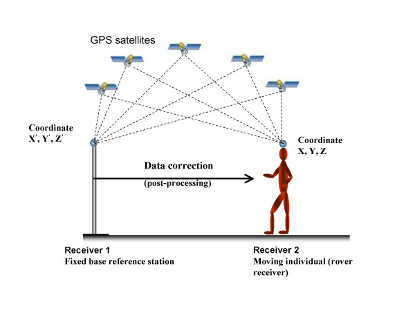
- 1- DGPS uses one or several (network) fixed ground-based reference stations (inknown locations).
- 2- The base station compares its own known location, to that computed from aGPS receiver.
- 3- Any difference is then broadcast as a correction to the user.
Correction signals can be broadcast either from ground stations, or via additionalsatellites. These services are privately owned and usually require a usersubscription.

Examples
- Satellite Based Augmentation System (SBAS),
- Wide Area Augmentation System (WAAS),
- Local Area Augmentation System (LAAS),
- European Geostationary Navigation Overlay Service (EGNOS),
- Omni STAR
- Coast guard beacon service
Why do we Need Differential GPS?
By using DGPS we can improve our positional accuracy from around 1.5m withstandard GPS to around 40cm with DGPS, without the need for post processing.In the case of the road survey van (top right), users can measure the amount ofroad wear and judge whether the road should be resurfaced just by driving overit. Just one day’s driving can replace a month’s manual work using traditionalmethods.There are many other applications like this. The labour saving is immense but at thesame time, previously impossible tasks are made possible such as the prediction ofearthquakes before they occur.